Each territory's size on the map is drawn according to its land area.

The size of each territory shows the relative proportion of the world's population living there.

Territory size shows the proportion of worldwide net imports of toys (in US$) that are received there. Net imports are imports minus exports. When exports are larger than imports the territory is not shown.

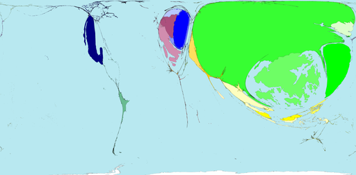
Territory size shows the proportion of worldwide net exports of toys (in US$) that come from there. Net exports are exports minus imports. When imports are larger than exports the territory is not shown.


1 comment:
too cool -very intriguing!
~kentuckymama
Post a Comment